On headwinds and glass
(Susan here)
First off, the stats:
Yesterday:
58 miles
9.7 mph
somewhere around 6ish hours
Today:
72 miles
6 h and 17 m
11.7 mph
As you can see from the last two days’ stats, yesterday and today were significantly different: that is, yesterday we were biking into an unbelievable headwind all day. With gusts approaching 20 miles per hour, it made for brutal riding: we’re talking downhills that you stand still on unless you’re pedaling and flats that you grind through on your granny gear (i.e., lowest gear). The unfortunate thing about finally reaching flattish land is that there really is nothing to block the wind. When we finally made Circleville for the evening yesterday, we felt as if we’d gone a hundred miles, not 58.
The sadistic weather was interrupted by a little sojourn we made into the Ohio Glass Museum in the lovely town of Lancaster. We saw it in passing and decided to see whether we could wait out some of the worst of the wind while learning something. The museum director, Bill, personally gave us a tour of the small but interesting space. Lancaster was the center of a major glass industry starting with the discovery of natural gas–a good solid fuel source for heating the furnaces–in the 19th century, and is still the home of Anchor Hocking Glass today. In line with the nature of the industry in that area, the museum has more of a focus on industrial and commercial glass production than the glass museum I’ve been to in Tacoma, WA, which is focused on art/decorative glass blowing. I entered a contest to win a glass bowl produced at the museum’s workshop, so maybe I’ll have a little souvenir if I’m lucky.
We were hosted last night by Dylan and Janet in their beautiful restored Victorian house in Circleville. We ate everything in sight; it was pretty great.
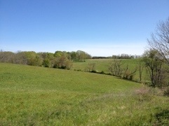
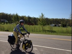
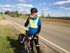
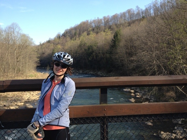
Some pics from yesterday:
Scenery: Note the beautiful blue sky for once.
Action shot!
Crackle glass at the Ohio Glass Museum:

Candy bar break: (We are very food-motivated; we usually promise ourselves a candy bar when we get to 10 miles or less to our destination. Such rewards were especially important yesterday.)
Today, not only was the wind relatively still, it was quite flat until we hit the steep roads to and from the Little Miami River. We really were flying. When we got to Lebanon, I at least still felt like I could have kept going. (Side note: Like many other American towns named after foreign places–I’m looking at you, Cairo, IL–Lebanon, OH is not pronounced like the nation of Lebanon. We learned this after several conversations with locals who asked us where we were going: “Tonight we hope to make it to Lebanon.” “Oh, Lebanin? OK.”) Tonight there’s going to be a thunderstorm–glad we’re not camping–and tomorrow it may rain some and the wind will pick up again, just as we get into the hills around Brookville. Sigh.
Scenery today: (Unfortunately the lighting isn’t good.) Imagine some cows, horses, and maybe some ponies and llamas in this picture; we saw them all today in pastures alongside the road.
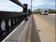
Singing bridge of Zanesville
Ok this link should work:
I’m not sure if this is the Main St. Bridge or the 6th St. bridge. Thx Larry for the assist.
Zany in Zanesville
(Susan writing)
We decided to stay here for the day because of the miserable weather forecast and Brice’s knee. We hit up a massage therapist, who was pretty helpful (i.e., painful, but in that good way) and saw the town. Apparently Zanesville and nearby Dresden were once the #1 pottery-producing area in the world, so the antique stores are full of ceramic things that are tempting until I think about carrying them on a bike for 2,000 miles. Also, the best-selling Western author Zane Grey is from here (he’s named after his great-grandfather Colonel Zane, after whom the town is named), and John Glenn is from down the road in New Concord, so everything around is named after the two of them.
Tomorrow we’re back on the road. We’re leaving rte. 40 (The National Road, built by Col. Zane) and are continuing on rte. 22 for a while. Our planned stops are: Circleville, Lebanon (the town in Ohio, not the country), Brookville (Indiana!), Columbus (there’s one in Indiana, too), and finally Bloomington, which is our next scheduled rest stop.
Here’s some pictures:
OK, the bridges in Zanesville over the Muskegum river are extremely cool, and not just because one of them is shaped like a “Y,” which apparently it’s famous in some circles for. They are cool because they sing! They are lined with these steel circles, as you can see in the picture below, and when the wind blows just right — as it did today, and vigorously — the circles produce sound just like if you were blowing across the top of a soda bottle. For some reason, they produce different pitches in the same chord series. The 6th St. bridge today was making an E major chord over about an octave and a half range. We took some recordings, but don’t know how to share them on the blog, unfortunately, so you’ll just have to imagine.
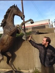
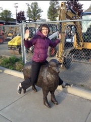
There was a sculpture museum in town that had a bunch of sculptures permanently installed on the sidewalk. We had fun with them. The sheep in the pic below was one of a herd, but this one was special, as you can see.
Zanesville!
(brice writing)
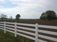
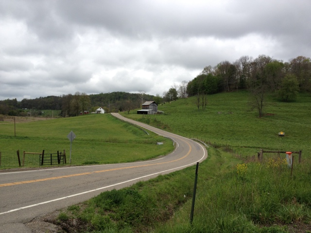
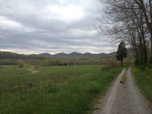
After the rough day yesterday, we made it 66 miles today to Zanesville, OH. The rolling hills continued (though they’re slowly diminishing as we head into the flatlands), but there was no rain so it was much easier to keep our spirits up. We also had gorgeous scenery the whole way – rolling green hills and picturesque farms, so picturesque Susan took a picture:
Also of note today:
Tomorrow will be interesting potentially. Here’s a list of things we’re prepared to handle, individually:
Even two of those we could probably hack, but there’s a chance of all 3 predicted, including snow (!). So we’re going to wait until we wake up tomorrow to decide whether we’ll be riding anywhere at all. Otherwise, we’ll hang here and wait for the better weather predicted for Tuesday. If we do head out, we’ll be riding for Circleville, due south of Columbus, where we’ll stay with Warm Showers hosts.
That’s all the news from here… we keep meaning to take more pictures but it’s a bit of a production in the cold weather to get the gloves off etc. Excuses excuses!
Google is out to get you and other lessons
(This is Susan. Brice is occupied watching the Red Sox v. Yankees game.)
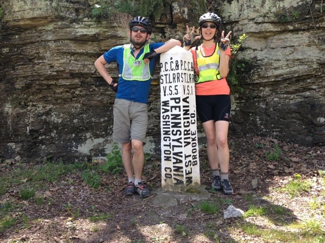
Geography lesson: There is a tiny sliver of West Virginia between Pennsylvania and Ohio: Who knew? Hence we had the enormous satisfaction of crossing a state in a couple* hours.
*Would have been faster if not for faulty routefinding and the subject of this post…
So, in writing out the directions to get us from Pittsburgh to Wheeling, WV, I got distracted somewhere in the middle — somewhere amidst Scott’s Franzia/mango sangria — and skipped over an entire set of directions in between the Panhandle Trail and Wheeling. What I wrote down indicated that the trail would take us all the way into town! Fantastic! Simple!
Well, when the Panhandle Trail ended in an ignominous snarl of weeds, we turned to Google to guide us into the city, which was still 30ish miles away. Since we’d been mostly following trails the whole way up, we hadn’t had much experience with routefinding. I cooked up some quick Google maps biking instructions on the iPhone, which would lead us along small country roads over to WV route 2 south.
We soon learned that Google’s overarching preference for the smallest roads possible in its biking directions had led us up an impossibly steep gravel road to an inglorious overlook above the Brooke County Landfill. Winding around the dump on increasingly hostile gravel, we were approached by concerned dump truck drivers. We’re all good, we assured them, and had them point us out the back gate of the truck area to our next road. Soon the idyllic paved country road will appear! we assured ourselves.
Nope, still enormous loose gravel, and, what’s more, more hills winding through a completely abandoned wilderness! Deciding to lose some dignity instead of skin, we proceeded to push our bikes up and down hills for the next 2 or so miles to avoid slipping on the gravel, until we did finally hit pavement. Long story short, we finally made it to Wheeling — after almost 70 miles of total biking (much of it into the strongest headwind we’ve hit yet) and a couple more wrong turns.
We were fortunate to have Harry and Karen, members of the touring cyclist hospitality network Warm Showers, waiting for us in their lovely Wheeling home along with an entire plate of deviled eggs, a platter of grilled chicken and other goodies, raspberry lemonade (!!!), and the eponymous shower. We stayed at their place last night, ready to set off and do 60 miles today. Having learned our lesson about roads, we reviewed the route carefully beforehand. Harry warned us of a few hills we’d encounter on the way.
We crossed into Ohio along what used to be the longest suspension bridge in the country (the 10th St. bridge, for those of you following along at home) and set off along route 40 for about 20 miles. After that mileage, route 40 would end somewhere after Morristown, and we’d take some county roads to Salt Fork State Park–which really looked on Satellite View as if they must be paved.
The hills were brutal. A steep, several-mile climb after we passed Blaine, which we knew we would face, was followed by unending rolling hills that would normally not be too demoralizing, unless of course you happened to be propelling 60 pounds or so of equipment with your own body.
Oh, and did I mention all of this was in an approximately 50-degree steady drizzle?
Our IT band syndrome has been doing ok after some cleat adjustments, but Brice had been developing some problems with his other knee, which he’s dislocated several times, most recently in an unfortunate game of paintball in 2011 during which he also contracted Lyme disease. Especially after the difficult day yesterday, he was having a lot of problems getting up the hills. We thought, ok, let’s make it to Morristown, eat lunch in a cafe, and reassess.
Turns out Morristown is one of those towns that you pass through before you realize you’ve hit it. Rte. 40 came to a stop at the end of a steep decline at nothing but the entrance to the next road on our route, county road 100 north–uphill and wouldn’t you know it, unpaved. At this point, also, we were very cold. We had waterproof stuff on, but it just didn’t keep out the cold. We hadn’t put our warmest stuff on because we were ok as long as we were moving, but now, at the bottom of this hill faced by yet another gravel road, I was starting to shiver. It was not the best moment.
Needless to say, we trundled back up the hill to a tiny roadside motel that is in what must be Morristown. The motel’s decor has not been updated since about 1960, but then again, neither have the room rates. We took hot showers, ordered pizza, and are watching tv. We’re ditching the camping idea and are instead heading west on state routes tomorrow, first to either Pleasant Grove or Zanesville, and then to another Warm Showers host in Circleville the next day. And yes, we are taking that gravel county road 100, but south, for 4.7 miles, but after that, no more county roads, and no more gravel roads as much as possible. I’ve also written out much more detailed directions that tell us where motel and food options are and exactly how much distance there is between various towns and other landmarks, just so we always have in mind what we’re about to get in to, distance-wise. We’ve also realized we have to put on our warmest gear early, not after we already get cold.
The nice thing is, the hills really flatten out from here on out. Circleville, in fact, seems to be almost completely flat. We’re looking forward to that.
We’ll see how Brice’s knee does tomorrow. Hopefully the extra rest today after the hard day yesterday does good and tomorrow we can actually get some miles.
Stats:
~30 miles today (69 miles yesterday)
9.7 mph ave today (11.9 mph ave yesterday)
~3 hours riding today (~6.5 hours yesterday)
Made it to wv, headed to oh
We spent the night in wheeling and are headed to salt fork state park. We’ll write more tonight hopefully.
Pittsburgh etc
(brice writing)
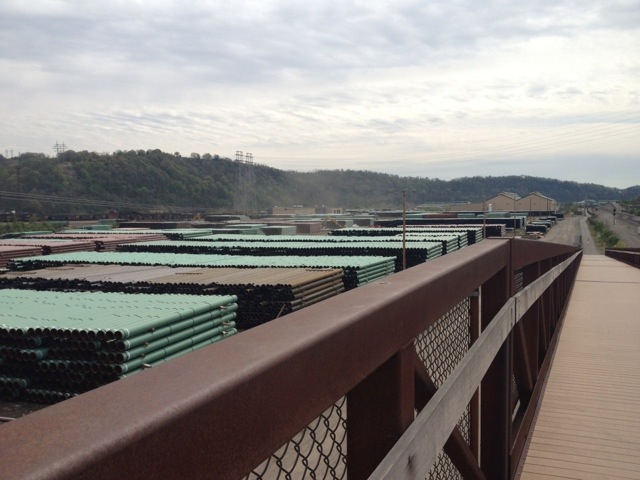
We made it in to Pittsburgh yesterday after our nutritious breakfast. The last 10 miles of the trail lead weave through abandoned steel works, active steelworks, and all kinds of train yards and factories:
After successfully navigating our way through the rubble, we found ourselves at the Great Allegheny Passage’s current end, which is in a random row of strip malls about 8 miles short of downtown Pittsburgh next to a PF Changs’. Most sources of information (including the GAP website) advise calling a cab to get into Pittsburgh at this point, but we had planned out a route that seemed like it ought to work without a high chance of death. We were extra confident because we’d run our directions past Adam, a native PGH’er we met on the trail who confirmed that google’s suggestion to “turn right down the alley behind the wendy’s and then walk your bike up the impossibly steep hill” was in fact the way to go.
After spending way too long in the lowest gears available, (Pittsburgh is seriously steep!) we arrived at Phipps Conservatory, where our friend and host Scott works. We spent a relaxing afternoon walking around the gardens waiting for Scott to finish working (he’s in charge of Integrated Pest Management at Phipps, which means he gets to do fun things like tend ladybugs and ‘good’ parasitic wasps that prey on insects that eat plants. Entomologists have cool jobs), and then a relaxing evening at Scott’s house where we practiced skills such as sitting on the couch while Scott cooked us some awesome veggie sloppy joes and sitting on the couch while Scott brought us wine.
We’ve decided to take two days off as we’re both suffering from some IT band syndrome; basically each of us has one knee that hurts quite a bit from biking so much. We’re RICE’ing heavily during the down time and also will be playing with cleat/saddle adjustments once we move on. Having had IT band issues before, we actually brought a mini foam roller, the primary tool for relaxing IT bands, on the trip. We’ve been using it diligently, but evidently not quite enough.
Otherwise our bodies are holding up pretty well; the last two days of biking have felt pretty easy, ignoring the knee pain, in terms of being on the bike and getting the pedals turned over. Our average speed is up over 11mph and we spent around 6 hours in the saddle the first two days on the GAP without real discomfort. So we feel reasonably confident that we’ll be able to hit 60 miles/day pretty easily once we get out on the paved open road.
If things go as planned we’ll head back out Friday morning for Wheeling WV (our target for this next leg is Bloomington, IN). We’ve had quite a bit of trouble finding a bike route out of PGH to the west that doesn’t cause local cyclists to react with alarm. We need to cross two rivers that are banded by railroads, freeways, and steep hills, and evidently there are no safe bike routes. So unless an undiscovered weakness presents itself, we may actually take a cab out to the outskirts of town in the interests of survival.
Some final thoughts on the first leg of the trip… by mileage, we’re already close to 10% done. We’ve both been too tired to really do any serious reflection so far, I think. Our day has been breaking down camp, riding/eating/riding/eating, setting up camp, and falling asleep, sometimes before sunset. That said, we were incredibly lucky to get to spend that first week with great weather, beautiful scenery, no cars, no routefinding, and very few steep hills. The C&O and GAP are set up to make cycling easy and their existence is remarkable feat of planning and conservation.
There was a weird time machine effect as we rode up the Alleghenies. Spring was in full swing in DC; most trees had close to full foliage by the time we left. But between the more northern latitude and the elevation, by the top of the GAP we were basically back in winter with no leaves and very few trees even budding. Pittsburgh is in full bloom too so we’re back in the present.
A couple of blog notes: there have been requests for GPS coordinates in our posts; I’ll work on figuring out how to add that easily. Also, we’ll include our next destination when possible. Thanks for all the comments as well; we appreciate them even if we can’t always reply.
Here are a handful of pics that we haven’t posted yet. We’ll try to be better about regular photography as energy levels warrant.
Breakfast: solved
Not our proudest moment but it did the trick:
We’ll be in Pittsburgh in an hour or so!
We’re in ohiopyle
(Brice writing)
About 70 miles in. We camped in confluence last night after our first 60+ mile day. We’ll see if we can duplicate that success on a sunny monday. Here’s us crossing into the mississippi watershed. 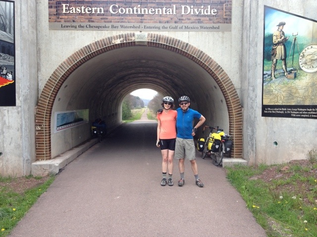
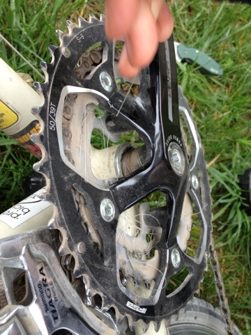
Gone fishing
We spent a relaxing night in Cumberland and are headed up the gap. Susan managed to get an impressive length of fishing line threaded through her whole drivetrain, do we’re taking a quick break to tackle that problem.